logo TERMCARD TRIP REPORTS VARSITY CITY RACE MAPRUN & POC SAFEGUARDING & WELFARE RESOURCES
Orienteer silhouette against the sun

UNI PARKS PERMANENT ORIENTEERING COURSE


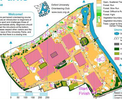
Oxford University Orienteering Club is responsible for a permanent orienteering course in University Parks in the centre of Oxford which was set up in 2003 and updated in July 2013. It consists of 20 wooden posts with plaques on top each with a unique number and letter code. There is a detailed map, which can be downloaded below, at 1:5000 scale showing the location of the posts and three suggested courses made from a selection of them. The idea is to use the map to navigate from the start/finish to the posts in the order listed for your chosen course as fast as possible, writing down the letter codes as you go to prove you have been to the post, then return to the finish. Please contact the secretary at secretary@ouoc.org.uk if you would like a list of the correct codes. You can also use a smartphone to take pictures of the posts and automatically time yourself and compare yourself to others. See SnapNav for more details.

Feel free to download to map, print it yourself and have a go!

Permanent orinteering post


Download map

Part of the POC map.
 
Start/Finish Location: Oxford University Parks South Entrance, here.

Total Number of Controls: 20 plus start/finish

Courses: Easy (1.4km, 6 controls), Medium (1.8km, 9 Controls), Hard (2.0km, 13 controls)

Map: Download PDF. A4 orienteering-style map, scale 1:5000, mapped to sprint standard with lots of tree detail.

Terrain: Flat grassy well-maintained park with lots of individual trees.

Time Yourself with a Smatphone: See SnapNav for more details.

Last Updated: July-2013

Suitable For: Complete beginners and intermediate orienteers, children and adults. Good sprint training for more experienced orienteers.

Any Enquiries: Contact our secretary.

Acknowledgements


Thanks are due to Matt Dillingham (Project Engineer, and President 2002-3) for having the idea, leading the project and constructing the marker posts, Ed Catmur (Information Officer 2002-3) for surveying and revising the map, members of OUOC for siting the marker posts, Jesus Orienteering Klubb (JOK) for providing the inital funding for the marker posts, and the Curators of the University Parks for granting permission.

Also thanks to Ian Webb for updating the map and the University Parks ground staff for helping to update the course in July 2013.