
The Isle of White Challenge
It had started the year before, Ray and I pottered about Poole harbor in his 3.4 M inflatable boat wit my 8 Hp engine on the back. As we left poole harbor through the tumult of the ebbing tide past the unstoppable chain ferry I looked at the Isles of Wight and said “lets pop over there”, a quick “not on your life” came the rebuff. “Its not far” I protested but Ray would not have any of it. Ray was new to this messing about in boats lark and I saw it as my task to build his confidence and teach him all I could about safely taking his boat on mini adventures.
We slowly passed the Old Harry rock on a warm sunny morning in late August. There was not a breath of air and the sea was a flat polished sheet only disturbed by hapless insects that had dropped into the still waters. The day was inviting, I did not know the waters and had come out past the edge of the only chart we had of the area. I was worried and had said to ray I was not happy but with the weather so kind what could happen.
We enjoyed inspecting the rock formations in the cliffs on our way to Swanage, and cut across the bay towards a red buoy off Peveril point as we approached we stood off several hundred yard to seawards. The wavelets grew into waves , which intern formed a messy chop. This was very uncomfortable and I felt that if that big one came along we ran the risk of being flipped. I turned the boat saying to Ray “ I don’t know what this is but I don’t like it we are heading back”. We fixed our selves to the front of a wave and surfed out into the once more quiet and benign sea.
We decided to stop for coffee in Swanage and see if we could find out what was going on by the “Peveril” red buoy. After a coffee and cake at a beach side café, we sort out the local tourist information office. “Oh that’s the Peveril ledge overfalls, It sank the Danish fleet in …” came the cheery reply from the man at the desk. We also discovered that a wooden dinghy had been lost there some weeks before. This was a sharp lesson no more sailing off the charts!
Over the next winter I would phone up Ray saying “I set a challenge to get an Ice-cream from Yarmouth Harbor leaving from Poole” always the reply came “NO”, with no discussion. I changed tack “Christchurch is not far from Poole lets try that on our next trip” “OK” said Ray. A few weeks past “You know Hurst point is only about the same distance again”, “yes we could do that as well” I now felt I had cracked the challenge!
I left things like that for a month or two, Ray bought some charts for the area and I taught him how to read them and appreciate the dangers. “You know Yarmouth is only across the Solent” Ray chirped one afternoon looking at the charts, I had done it ! now I thought lets really set a challenge. “Ok if we are going to do that why don’t we go all the way round the Isle of Wight”, “OK” ray replied without further comment. I was stunned!
Over the next month or so I pored over the chart as I had only sailed the Solent whilst doing my level 5 dinghy sailing course some years before (Oh yes I passed). Asked questions on news groups read the fine books Solent Hazards and Wight Hazards, by ……. Finally we selected a weekend that we could rent a friend’s flat in Poole, checked the tides, and hoped for a good forecast.
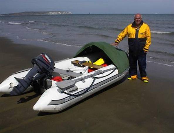
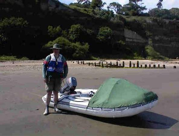
Ray in the meantime persuaded his wife to make a canvas cuddy for the inflatable this was to keep him and the provisions dry. It worked very well but sometimes acted like a sail! I decided on a course and programmed it into my GPS along with a chart of the Isle of Wight. We made up a list of equipment (VHF, Flares, Mobile phones, food, water. Etc.).
On the 25th June 2003 we setoff from Oxfordshire arriving at Poole at about 11 am. We just had to get on the water. Flinging our weekend clothes etc into the flat we dashed to the foreshore, inflated the boat fixed on the engine and set off for a trial run to Christchurch. The sea was calm and we easily made our port. After a coffee and bun I suggested we presses on to Hurst Point. We had plenty of fuel, we had only used 1/3 of a tank (mistake no 1). We continued to Hurst point in pleasant warm calm conditions and arrive on the north shore about an hour later. We wandered about looking at the old fortification, talking to the anglers (who maroon them selves there to fish all night).
A chill wind started to blow up. We thought we had better go! The placid sea was now a classic wind over tide chop. We could not plane the boat, due to the sea state. The engine struggled to take us out of the Solent, and the sea grew; it was about 7:30pm. Looking to the shore we progressed at a slow walking pace the GPS confirmed 1 knot. The sea was now breaking on the shore and rocks, looking highly uninviting. The wind now blowing hard on our bow/port quarter soaked us with spray.
I had checked the VHF before we left and it was working fine. Now I switched it on; it was DEAD. “Where is your phone” I asked Ray “In the pod” came the reply. (The pod is a waterproof cylindrical container in which we keep emergency kit) after a brief search ray said “and the pod is in the car” (mistake no 2). The pod also contained my phone and the flares. We were running out of fuel, and a lee shore threatened, we had no means of raising the alarm. The boat was in no immediate danger as long as the engine kept going. I carefully studied the beach for places that we could land through the surf should the fuel run out. The tank was almost empty, 30 minutes at the most. I felt such a fool, an idiot, the sort of person that I raise my eyebrows at when reading the lifeboat reports.
Then very quickly the sea settled a little as the wind dropped, we could plain the boat! In 20 minutes we came into Christchurch, the light was beginning to fade we had no hope of making Poole in the light and didn’t feel like doing so. We asked the fishermen on the quay where the fuel was, “No fuel here” came the reply we landed at the slipway and dismantled the boat, Ray took a taxi to poole and returned with the car at about 11.
Whilst sitting on our kit, waiting for the car I checked the fuel tank, it only contained vapor. We will need 2x25L tanks tomorrow I thought, and a 12L spare.
We returned to the flat, after stopping at a chip shop that had just closed but was willing to sell us the remaining fish and chips for a knock down price. As I got read for bed I watched a fox scavenging the bins by the beach.
The dawn greeted us with a smile; sunny calm and growing warmth. I checked my reserve VHF and fixed the bad contact on the one that had failed the day before. The weather forecast was excellent. This time we went through our list we had plenty of fuel, and the emergency “pod” got packed.
We left Poole with the out going tide through the harbor mouth at exactly 9:00 BST. For the first hour the sea was flat and we plained at about 13 knots. We continued like this to the “North Head” buoy. Turning south at the NE Shingles to avoid the race and passing in side the warden buoy.
Now another part of this challenge was to “thread the needles” we aimed for the appropriate gap and swept along on the tide shot through briefly admiring the cormorants / shags that seemed to line the sides of the needles. South of the Isle of Wight the sea rolled to a pleasant southerly. It was at this point I realized we had forgotten something: the sun block. My Tilley hat protected my face but my knees burned. Ray was turning a deeper shade of tan. We had planned a stop in Freshwater bay, which we pressed on with but the surf generated by the southerly breeze made our landing a little wet.
As usual our stop included a coffee and a cake. Trying to launch proved difficult, the idea was to run the boat through the surf, then quickly jump on, start the engine and be off. We had not anticipated how steep the bottom was, we ran out of depth only a few yards from the shore and were thrown back 3 times before we manage to start the engine and leave. Our provisions remained dry but a large amount of water entered and remained under the air deck. It was 15 minutes before the water drained through the transom hole and we could plain again.
As we proceeded away from Freshwater the engine died as we finished the 12L tank. The silence was intoxicating; the solitude accompanied by the gentle rocking in the swell and the deep clear water was paradise in the sun. But our schedule did not allow for such delights. The first 25L tank was connected and as we roared away, I thought of all the times that I had been in such conditions under sail.
As we headed for St. Catharine’s point I thought I saw a powerboat heading towards the island at speed all the way to the beach. Ray and I watched a second then a third, this was no boat it was a breaking wave! Ray then held up the GPS. The electronic chart showed we had come inshore of our planned course and were rapidly approaching the Brook ledges. A turn to starboard took us head on to the swell made step by the shallow water.
We soon returned to our course on the way Ray exclaimed “we’re going over a wreck” he showed me the chart, he has got the hang of this I thought.
We approached St Catharine’s point hoping to be inside the race. I did not think that it would present us with a problem but we needed to keep plaining to remain on schedule. We had a couple of hours for delays but I did not want to use them just yet. As we passed close inshore of the point I though how few boats seemed to venture south of the island. The two boats that we could se both took the outside route round the race. I noticed Niton on the chart a familiar name for those that practiced for the VHF radio license.
We now enjoyed looking at the houses and hotels perched on the steep slopes of the island. Here and there white plastic drainpipes could be seen snaking down the slopes. Ventnor proudly displayed its name to all those at sea. We came uneventfully to Shanklin and pulled the boat up the beach for lunch. My legs now stung with sun burn. We spent about an hour at Shanklin. Before we left we connected the second 25L fuel tank estimating that would last the rest of the journey. Launching was easy from this beach the southerly breeze could not kick up surf here.
We crossed Sandown bay and admired the white cliffs at Whitecliff bay. This was a very easy pleasant section of our trip, only marred by a profusion of plastic bags just below the surface of the water. (I had once ruined the gears of a sea gull engine on a Wayfarer that hit a carrier bag off north Norfolk). Entering the east Solent we counted 8 ferries plying there trade across the channel. As we approached Spithead I noticed brown water ahead a 90o turn to starboard got us clear of the shoal. Ray held up the GPS we had again come inshore of our planned course.
The next hour was spent in the company of hundreds (it seemed) of other boats personal watercraft and ferries, and a rope tens of yards long with a float on the end! We manage to stop just before the rope got us. Both of us were particularly vigilant jugging the speed of the ferries and adjusting speed as necessary.
As we turned south east past cows a typical Solent chop developed. We moved to the north side to take advantage of the slower tidal stream that was now set against us. The sky clouded over somewhat making our passage down the west Solent a slog. The usual turbulence was in evident passing Hurst point. But once out into Christchurch bay we could once again plain. How different this was from the previous night. We stopped at Christchurch for a Coke and packet of crisps at the local pub.
The sun grew low as we plained across Poole bay the setting sun shining in our eyes and reflecting off the water we had forgotten our sunglasses. At 19:35 we drew ashore in Poole harbor. We packed the boat into the back of Ray’s car. Showered and had a celebration meal at a Thai restraint. We had completed our challenge.