|
Little Wittenham wood falls on four OS Land-Line
tiles, su5692, su5693, su5792 and su5793. I have downloaded these (in NTF
format), translated them into MapInfo export format and then merged them
into a single MapInfo table.
Create a folder on your zip disk called "Data".
Click here to download a zip file (Little_Wittenham.ZIP) and save it to the Data folder. The zip file contains the following MapInfo files:
| Little Wittenham.DAT |
173 Kb |
| Little Wittenham.ID |
11 Kb |
| Little Wittenham.MAP |
352 Kb |
| Little Wittenham.TAB |
1 Kb |
|
|
Unzip (or "extract") these files and save them in the Data folder.
You may need to consult the Help facility on your decompression software for
details of how to do this.
Open MapInfo. In the Quick Start dialogue box select Open a Table and press the Open button.
Select the file Little Wittenham.TAB and
click Open.
A window should open showing part of the
Little Wittenham map. This window is probably too small for you to see
very much. In order to see the whole of the map drag the borders of
the window
out to increase its size and then right click in it to produce a pop-up menu (like the one shown on
the right). Select View Entire
Layer.... A list box will then appear in which you should select the layer
Little Wittenham.
|
|
- You should now be able to see the whole of the map. Once you have
identified Little Wittenham Wood on this map zoom in on it using the zoom
tools on the Main toolbar. Zoom in and out until you are satisfied that
the whole wood is nicely framed in the window. You can also use the "grabber" tool to move the frame of view.
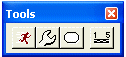
|

MapInfo's zoom tools
 MapInfo's grabber tool
|
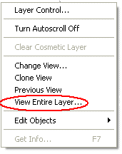
Visit the English Nature
homepage and select the GIS Data option under Publications and Maps.
When you click on the link above a new window should open. You can continue to
follow these instructions in this window.
Enter your full name, organisation and email into the registration boxes and then select
Option 1 (Data delivered in zip files based on 100km squares). Press Register.
|
|
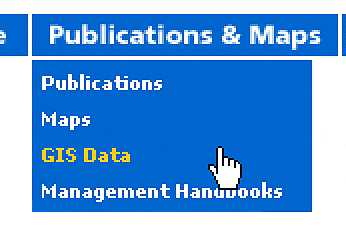
You will be taken to a Dataset Download Selection
page where you should select Sites of Special
Scientific Interest as the dataset type,
MapInfo TAB as the format, SU
as the 100 km square and the Internet
as the download option. After you have read the terms and conditions of
use, press I Agree to download the
data.
|
|
Check that the file sussstab.zip is available and click
Download.
You will be asked "You are downloading the file: sussstab.zip from www.english-nature.org.uk Would you like to open the file or save it to your computer?" Select
Save and save the zip file to the Data
folder on your zip disk.
|
|
The zip file contains the following MapInfo files:
| Susssi.tab |
558 Kb |
| Susssi.dat |
225,321 Kb |
| Susssi.map |
2,567,168 Kb |
| Susssi.id |
3,700 Kb |
Unzip the file and save these to your Data folder.
|
|
-
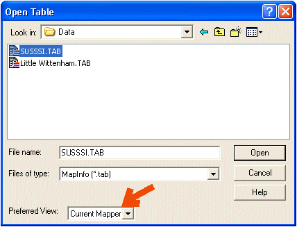
Return to MapInfo and make sure that the file
Little Wittenham.TAB is open and that
Little Wittenham wood is nicely centred in the window. Then select
File followed by
Open Table... The dialogue box pictured
on the left will appear. Select Susssi.TAB
and Current Mapper as your preferred view. Click Open.
A new layer should open in the current window showing the area of
Little Wittenham designated as a Site of Special Scientific Interest
shaded in green.
|
|
|
|
- You can arrange and annotate the contents of one or several layers and
windows into a single map for printing in the Layout Window. Open a new layout
window by either selecting Window and then
New Layout Window... from the menu bar or
by pressing the New Layout button on the
standard toolbar.
|
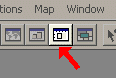
The MapInfo New Layout button |
An option box will appear asking Create a new
layout window containing.... You should select the first option
One Frame for Window. The new layout window will appear (often very small!). Drag the window to
a convenient size and then zoom in on the preview using the zoom tools. Your
map should be shown exactly as it will appear when printed. You can adjust the
way the page is set up by selecting File
and then Page Setup.... Add a suitable title to your map using the Text tool on the Drawing
toolbar. Include the line "Map created by <your name>" in the title. Create a folder on your zip disk called "Maps". Select
File and then Save
Window As.... to save this map layout. A Save Window As.. dialogue box will appear. You can choose to save an
image of your layout at the default size or specify a custom size. I suggest
you accept the default. Select Same as Window
and press Save.... Give your file a sensible name (such as SSSI) and save it to the Maps
folder on your zip disk. I suggest that you select
JPEG File Interchange Format (*.jpg) in the
Save as type: box. Print a copy of your map and hand it in to your tutor. Close the layout window. The map on screen is formed from a combination
of different files. You can save this combination so that you can return to it
in future. MapInfo will remember exactly how you put the map together but it
will not alter the original data sources. Select
File on the menu bar
and then Save Workspace... Choose an appropriate name and save your workspace
as a *.wor file. When you open this *.wor file in future MapInfo will open all
the necessary layers in exactly the way that you have them open now.
|
Going further
You might like to experiment with creating a
scale bar for your map. The scale bar is drawn on the Cosmetic Layer of your
mapper window (you cannot draw a scale bar in the layout window). Follow these
instructions:
- Click on
Tools and
select Tool Manager....
- A Tool Manager dialogue box will appear
showing which tools are available (if there are no tools shown consult your
tutor). Scroll down the list to ScaleBar
and check the
Loaded
box.
-
Click
OK. A new
toolbar should appear. Select the Draw
Scale Bar button.
-
Click on your map where you
would like the scale bar to go. A Draw
Distance Scale in Mapper dialogue box
will appear in which you can adjust the characteristics of your scale bar.
-
Click
OK and
the scale bar will be drawn on your map.
-
IMPORTANT Click on the Select
(pointer) tool in the Main toolbar before you do anything else. If you click
on the map before you do this you will create another scale bar, and another,
and another.........
-
If you want to delete a scale bar, right
click your map and select Clear Cosmetic Layer.
-
If you want to save your scale bar when
you close your map you must select Map
on the menu bar and then chose Save Cosmetic
Objects....
|