
How a GPS works and sources of error
On this page you can learn more about:
Global Positioning Systems in forestry |
|
The advantages of extremely accurate position information are already well known in agriculture. There is spatial variability in soils, topography and drainage across many agricultural fields. This pattern can be measured and mapped and fertiliser and pesticide applications adjusted to very local requirements, reducing the total amounts applied. This cuts both costs and environmental impact. Precision farming systems require the use of very accurate location information. Geographic information systems and GPS are used to control applications. They have also been used to control planting and harvesting and co-ordinate operations around the farm. Foresters are only just beginning to realise the potential of this technology. Foresters frequently work over much larger areas than farmers and in landscapes where visibility is low and it is easy to lose track of staff, equipment and products. GPS and GIS provide a means to control operations at a very local scale and maintain real-time information on where staff, products and machinery are. One of the problems affecting the use of such technology in forests is the difficulty of receiving GPS signals beneath a forest canopy. Often a GPS receiver requires at least 20 to 30 minutes at a single location to acquire an accurate position fix. The development of 12 channel GPS receivers with built in antennae has reduced but not eliminated this problem. In the following practical we will use a GPS to record the positions of veteran trees. In addition to being of intrinsic conservation interest, veteran trees may also host a large number of associated saproxylic invertebrates and lichens. Where veteran trees occur within woodland SSSIs and SACs, their maintenance is being promoted by including them as part of the conservation objectives for the site. Visit the Woodland Trusts Ancient Tree Forum site for more information. English Nature have prepared a very useful handbook on the management of veteran trees that can be downloaded from their Veteran Trees Management website. Little Wittenham Woods contain a large number of veteran trees and it would be useful to include them on the management plan to ensure that appropriate management decisions are made for those areas in which they are found.
|
If you would like to see examples of GPS in forestry and agriculture select one of the links below. |
How a GPS works |
|
|
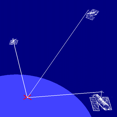
The Global Positioning System (GPS) was designed and built by the US Department for Defence as an aid to precision navigation in areas that were poorly mapped. The system uses a constellation of 24 NAVSTAR satellites in six orbital planes around the earth. Each orbit is occupied by four satellites. A GPS handset can calculate exactly how far away it is from a satellite by timing how long it takes for a radio signal, broadcast by a satellite, to be received. Each NAVSTAR satellite contains an atomic clock, accurate to three billionths of a second, to ensure extremely accurate timing of its signals. |
You can find a more detailed
technical account of how the Global Positioning System works by visiting
Colorado University's Geography Department GPS site.
|
|
Each satellite also broadcasts its exact position in its orbit above the earth. When a GPS has received signals from three or more satellites it is able to calculate its position by triangulation. The number of satellites "in view" depends on the time of day and where you are on earth. If you have an unobstructed view of the sky then your handset should be able to receive signals from at least five satellites at all times. Unfortunately satellites are often hidden behind mountains, buildings and even forests. Many relatively inexpensive hand-held receivers can now track up to 12 satellites simultaneously (12 channel receivers). The more satellites that can be tracked the greater the chance of an accurate position fix.
|
 |
Sources of error |
|
The accuracy of the calculation should be ±22 m horizontally. However, refraction of the signal in the ionosphere, reflection causing the signal to arrive several times (a 'multipath' signal), poor satellite geometry (when visible satellites are lined up in a row) and poor signal reception can degrade accuracy. Poor signal reception can be caused by blockage (by hills, trees and even your own body), weak batteries or interference from other electronic equipment in use nearby. Some hand-held receivers have small antennae and these are prone to poor reception and multipath errors. It is best to avoid situations in which these types of problem are likely to occur. Larger antennas provide better reception and are usually better shielded from multipath signals. Where a very high level of accuracy is important it is possible to compensate for some of the errors in the signal by using two GPS receivers. One of these should be located at a known control point. This can be used to calculate the size and direction of any measurement error which can then be subtracted from measurements made with the second unit.
|
|
GPS co-ordinate systems |
|
Every map has a co-ordinate system that allows the position of an object to be described. The co-ordinate system is based on a model of the earth's shape such as flat, cylindrical or spherical. The most commonly used co-ordinate system is latitude and longitude, based on an ellipsoid model. The model (referred to as a map datum) defines the size and shape of the mapped earth and the origin and orientation of the co-ordinate grid. Hundreds of different datums have been developed for different purposes and different parts of the world. Many modern GPS receivers can be set to use a range of map datums and co-ordinate systems. By default most use a system of coordinates called the World Geodetic System 1984 (WGS 84). The reference system for Ordnance Survey maps is OSGB36 National Grid. Using the wrong map datum can result in substantial position errors. It is most important, when recording position information with a GPS for use with an Ordnance Survey map that you record the data using the appropriate map datum and co-ordinate system. Your GPS User Manual should tell you how to set this. It is possible, however, to convert data recorded in one system to another. |
|
| Web page designed and written by Nick Brown. Last updated on 1st March 2002. Any comments and suggestions to nick.brown@plants.ox.ac.uk. |