|
|
You will need:
- A GPS set to OSGB36 map datum
- A copy of the Little Wittenham compartment map
- A notebook and pencil
- A dbh (diameter at breast height) tape
- Divide the class into groups of three. Each group should visit a subset of
compartments in Little Wittenham wood. Spread out and sweep through each
compartment to locate all veteran trees.
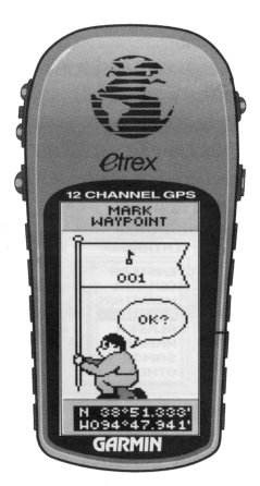
- Standing at the base of each tree record its position using your GPS. With
the Garmin eTrex this is done by pressing the PAGE
button until you reach the MENU page.
Select MARK and the
MARK WAYPOINT page appears. Use the
UP button to select the waypoint name field
and press ENTER. Edit the waypoint name to
a sensible code that you will recognise (e.g. VET01). Select
OK to accept the name and then
OK again to record the waypoint. These
instructions are given in full on page 21 of the owner's manual.
NB: It may take the GPS many minutes to determine your position if
you are beneath a thick forest canopy.
- Record the species and dbh of each veteran tree and sketch its approximate
position onto your compartment map. Use the same code name to identify each
veteran tree on your compartment map and in your field notes as you used for
the GPS waypoint.
|
 |
|
You will need:
- Your GPS with stored waypoints for veteran trees;
- A GPS serial interface cable for connecting to a PC;
- Software to enable you to download data from your GPS to your PC. I
recommend that you use GPS Utility, a simple to use freeware program that is
available for download by clicking
here.
The following instructions describe how to download waypoints using GPS Utility. If
your GPS is supplied with software for interfacing with a PC you should follow
the instructions in your user's manual instead.
|

GPS Utility |
- Connect the serial cable to the com1 port of your PC and the data
connector port on your GPS.
- Switch on the GPS and start the GPS Utility program.
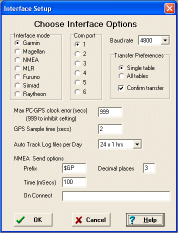
- Select GPS and then
Setup ... from the menu bar. An Interface
Setup dialogue will appear (like the one shown opposite) in which you will need to select the appropriate
interface type, communications port and baud rate. Consult your user's manual
for information on the correct settings for your GPS. Click
OK.
- Select GPS and then
Connect to connect your computer to the GPS. The
status bar at the bottom of the GPS Utility window will show when the
connection has been made successfully.
- Once the GPS is connected select GPS and then
Download Waypoints from the
menu bar. Confirm that you wish to download waypoints and click
OK.
- The status bar will show progress in downloading your waypoints. When the
download is complete a table will open showing the waypoint names (ID) and
their precise positions (Coordinate).
- Select View and then
Datum to set the map datum to Ordnance Survey Great
Britain. Select View and then
Coordinate Format to set the format to British
Grid.
- Select File and the
Save As... A Save As dialogue box will appear.
Choose an appropriate file name and save the table as a MapInfo (mif) file
(e.g. veteran_trees.mif) on your zip disk.
|
 |
|
|
|
You will now create a MapInfo table containing the GPS data and then create and
print a compartment map that displays the positions of the veteran trees.
- Open MapInfo and in the start up dialogue box open the workspace compart.WOR.
- Select Table and then
Import... to display a dialogue box. Use the
Look in: list box to browse your zip disk
and select veteran_trees.mif. (If your
file is not shown make sure that you are asking MapInfo to look for the
correct type of file). Select Open.
- An Import into Table dialogue box will
open. By default it will suggest that you import your mif file into a table
called veteran_trees.TAB. Accept this
option by clicking Save.
- Select File and then
Open Table... When the
Open Table dialogue box appears make sure to
select Current Mapper before selecting
your new veteran_trees.TAB file.
- The positions of your veteran trees should now be shown on your map
(usually with a black star symbol).
|
|
|
You are now going to use MapInfo's selection features to print a map that shows the position of all veteran trees >80 cm dbh. First of all you will have to add species and dbh data from your field notes to the veteran_trees.TAB file.
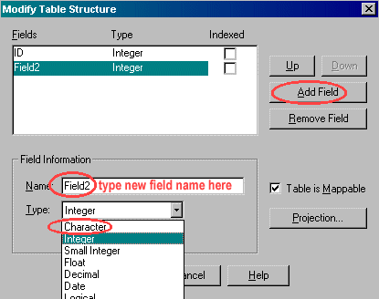
Open the veteran_trees table in Browser view. The only information about each point will be ID which is a tag assigned by MapInfo. Species and dbh information about each veteran tree can be stored in the MapInfo table. To do this you will need to add more columns to the table. Select Table, Maintenance and select veteran_trees and click OK. In the Modify Table Structure dialogue box click on Add Field. Under Field Information enter the Name e.g. species and for Type select Character. This will produce a 3rd option Size where you need to enter the maximum width of data entries in this column. 25 should be enough for species names. Click Add Field again to add another field for dbh, this time the field type will be Integer. Click OK to exit the dialogue box.
|
|
Because you have modified the table structure, MapInfo has closed the table veteran_trees. Re open it in the current mapper and again in browser view. In the browser version you can add the information you collected about the veteran trees in the species and dbh columns by clicking on the appropriate cell and typing in the data.
-
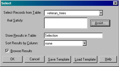
MapInfo can select all the veteran trees with dbh >80 cm. To do this, select the Query menu and then Select.... In the select dialogue box that opens, enter the following information: in Select records from table: choose veteran_trees. For that satisfy: we'll come back to in a minute. Store results in Table: choose selection and Sort results by column choose none. Make sure Browse results is selected. Now click on the Assist... button.
|
|
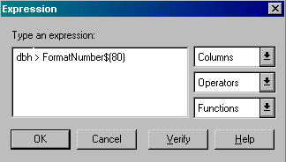
The expression dialogue should have opened up for you. Here you can type an expression which will give MapInfo rules to select the individuals you are interested in. To ensure that the syntax is correct, let MapInfo formulate the expression for you. In the Columns drop down box select dbh, in the Operations drop down box, select > and finally in the Functions drop down box select FormatNumber$. This will produce an expression in the Type an expression: box. At the end there should be a FormatNumber$() expression, enter 80 between the brackets. This is the limit of individuals you are trying to find. Click the Verify button to check the expression is correct. MapInfo should say that the syntax is correct. Click OK in this announcement box. Click OK to close the expression dialogue box. Back in the select dialogue box the expression will appear in the that satisfy: box. Click OK.
|
|
A new browser window should appear called Query1 and all the veteran trees over 80 cm dbh will be selected in the mapper window. Now you need to print a map that shows all these individuals. To do this, save the results of your query. Select File and Save Query... and call the new table veteran_80.TAB. Now close all the tables currently open in MapInfo.
Next, open the workspace compart.WOR which has all the background layers that you want to display behind your selected veteran trees.
Next open the query table veteran_80.TAB in the current mapper. All the veteran trees you previously selected should now be visible as black stars. If the trees don't appear on the top layer, then use layer control to bring them to the top.
Now save the workspace and print a map with the veteran trees with dbh >80 cm. Look back to practical 1 if you need to review how to do this.
|
|
|
|
|
Now you can to create another layer on your map which incorporates the other features in the wood such as rides and point features which you have collected GPS data for.
Open MapInfo and in the start up dialogue box open the workspace compart.WOR.
Click on the title bar of the mapper window and the select the layer control button and make the Cosmetic Layer editable. Then click OK.
Now you can mark the features on the cosmetic layer. For example pick one ride to draw. Select the drawing tool that best fits the feature, i.e. a line
 , a polyline , a polyline
 or symbol or symbol
 and trace out the ride. and trace out the ride.
Save the object you have drawn on the cosmetic layer by selecting Map and Save Cosmetic Objects.... In the Save Cosmetic Objects dialogue box select NEW in the Transfer Cosmetic Objects to Layer: option and then click Save.... Save this MapInfo table as features.TAB along with your other files. Select layer control again and change from editing the Cosmetic Layer to edit features. Click OK.
|
|
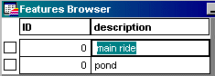
Open the features table in Browser view. In the browser window there will be table with one data row, if you select this item, the ride you just drew will be highlighted in the mapper window. Now you can store information about this feature. To do so you need to add another column to the table. Add another columns to the table called description which will hold information about each feature. Make this a Character type field. Instructions for adding columns are found above in this tutorial.
|
|
Because you have modified the table structure, MapInfo has closed the table features. Re open it in the current mapper and again in browser view. In the browser version you can add information such as "main ride" in the description column.
|
|
Select layer control and make the table features editable. Now you can add the remaining rides and point features onto the map using you GPS points as a guide in the same way as you drew the 1st ride (select mapper title bar, select drawing tool, draw feature). Every time you add a new feature a new row will appear in the browser version where you can enter information regarding the feature. If you hover with the mouse over each object, the information you entered will pop up.
|

|
Save the table features and the workspace as compart_and_feat.WOR.
|
|